Gib mir Bescheid, wenn der Produkt wieder verfügbar ist
Email:
Lageragent erstellt. Wir schicken eine E-Mail, wenn der Artikel wieder verfügbar ist.
Die Funktion setzt voraus, dass Sie angemeldet sind. Erstellen Sie einen Nutzer und verwenden Sie unser intelligentes Listensystem, um zukünftige Einkäufe, regelmäßige Einkäufe oder Wunschlisten zu verfolgen. Jetzt registrieren Anmelden
See your vessel’s precise, on-chart position in relation to navaids, coastal features and restricted areas with premium features found in this detailed marine mapping data. Includes all of the features of our BlueChart® g2 product, plus 3-D perspective above and below the waterline, Auto Guidance, high-resolution imagery, and aerial photos of ports, harbors, marinas and landmarks.
- Shaded depth contours, coastlines, spot soundings, navaids, port plans, wrecks, obstructions, intertidal zones, restricted areas and IALA symbols. - Seamless transitions between zoom levels and more continuity across chart boundaries. - High resolution satellite imagery for a realistic view of the land and water. - Aerial photos of ports, harbors, marinas, waterways, navigational landmarks and other POIs. - Auto Guidance technology searches chart data to suggest the best passage to a destination. - MarinerEye view 3-D perspective for a quick, easy position fix. - FishEye view 3-D perspective for an underwater view of the sea floor. - Safety Shading* enables contour shading for all depth contours shallower than your defined safe depths. - Fishing Charts* to scope out bottom contours and depth soundings with less visual clutter on the display. - Plan and organize routes from your computer with HomePort™ (sold separately).
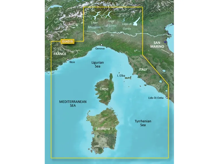
Coverage Detailed coverage of the Mediterranean coast from Le Lavandou, FR to Lido di Ostia, IT including Monaco and complete coverage of Corse and Sardegna. Also includes coverage of Lago Maggiore, Lago d'Iseo, Lago di Como and Lago d'Garda in Italy.
Das Produkt hat folgende Artikelnummer in unserem System
SKU:
010-C0795-00
EAN:
753759069759
Hvorfor oplever jeg at den umiddelbart samme varer findes på forskellige varenumre?
Producenterne udgiver ofte den samme varer med forskellige varenumre, typisk handler det udelukkende om forskellige versioner af emballagen. Eksempelvis kan emballagen være målrettet forskellige lande.
Vi forsøger bedst muligt at samle varerne, men det kan opleves at den samme varer figurerer på forskellige varenumre i vores system.